 All pictures from my cell phone camera.
It's nice to have a week off from school. I am visiting my hometown of Bishop California, located on the eastern Side of the Sierra Nevada Mountains in the Owens Valley about 300 miles North of the city of Los Angels.
The Owens Valley at Bishop is about 4,100 feet above sea level. The neighboring Sierra and White Mountain ranges soar to over 14,000 feet. This place is known as the DEEPEST VALLEY in the world (my mother makes me add). This even with 1000's of feet of alluvium (eroded Sierra and White mountain rock).
A friend(David Piercy) said take some pictures. So I decided to go on a quest. The old Silo's of long gone ranches. These structures have always captured my sense of wonder for their history and sheer physical mass. These farm silos are the only remnants of the many ranches that spotted the floor of the Owens Valley. (see a painting of "The Matlick Ranch" below painted by my father Ernest G. Kinney).
These were too difficult for the City of Los Angeles Dept. of Water and Power to tear down as they bought the water rights to the valley in the 1920's and 30's. My Dad said they tried to tear them down years before I was born and it was a near impossible task. So they stand as mostly lone sentinels of the valley sage covered prairie lands. So Here:
In my dad's painting notice the silo behind the barn. It's amazing to imagine a ranch like this near each of the silo's you are about to see.

Below Quad Silos. Must have been a big ranch. Usually the openings for the silo's faced east. The "windows" would be covered with wood to keep grain/produce in. These are near the river close to Warm Springs road just East of the Owens River (referred to now as the river). This are only 11 concrete rings high, but are the only ones we found set into the ground about 2 rings deep. For the locals you can see the Peaks of Mt. Tom and Humphrey's between the silo's on the 2nd pic.


Below Twin Silo's. We had to cross a creek on a 3 foot wide pipe to get to this one and go through a field of fresh cow-pie land mines. I like the plank at the top . I am leaning against the side for size reference. These are about 14 concrete rings high. It is easier to count them at the site than on the pictures.


In this you can see a small glimpse of Airport road north silo between me and the twin silos. The cows tolerated us and scared my son. In the distance we could hear the distant cry of a cow and I told him to FREEZE...it's a Sleestak and they are deadly!
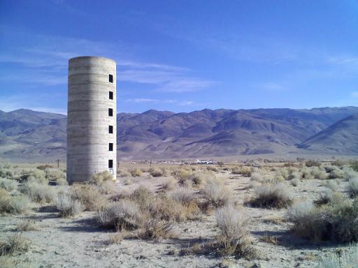
Below is Airport Road Silo middle. (if you exit the airport and cross line street onto the south going dirt road you will see 3 silo sites, one of which is the twin above.) My son Anthony is there for scale. You can barley see Mr Tom and all of Basin Mountain. This one is 11 1/2 concrete rings high.

I love the close up of Anthony (below left) inside the silo. Note the re bar that makes it rally strong. Most of these are full of old beer cans, burnt tires,and spray paint cans.
The Silo below right, the one I tried to be artsy with the sun in the "window" is Airport road north, closest to the airport. It is about 11 and a half rings high.


Below 2 pictures: Ahh, probably the most visited silos of the area by high school kids looking for a place to "PARTY" These are the twin silos near the 2nd artesian well (these wells are springs fed by the water level being higher in the surrounding mountains. There are several of these about the valley. These silos are a graceful 14 concrete rings high and one of only 3 that do not have their openings face east. These face west.


Below is the 1st artesian well just off line street on the west side of the river. The pipe use to be perfectly round but local young idiots (like me) tried to pull them out. I only succeeded in adding one dent to it but MANY to my dads ole white truck. The river is about a stone throw to the right of this photo.

Below is the Silo on Highway 6 just west of the "community" of Laws. You can see the chemical plant and the railroad museum in the background if you can zoom way in. The close-up below is pretty cool too. I think these things will out last the pyramids.

Below are the Twin silos on highway 6 just north of WYE road. People live on the property so I did not get too close.

The Picture below is the Dixon lane silo close to highway 6. I had a closer pic but it got deleted (i hate my cell phone). Up close it looks like the Laws silo but with gray paint covering graffiti. On Warm Springs Road about 3/4 mile east of highway 395 is a short single silo in a working ranch but I lost my photo of it too. This was fun to do today for both me and my son.

Thanks for this info on this type of silo. I came across one of these in Simi Valley in a hidden canyon today but really couldn't figure out what the windows were for. Long abandoned but built to last!
ReplyDelete